PrimaGIS
Create web maps for Plone using OGC compliant web services or a variety of locally hosted GIS data backends, including your Plone site catalog. Python Cartographic Library
Packages for programming applications such as PrimaGIS, or for use with the Python web framework of your choice.
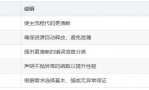
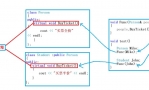
后者是基础类库,前者是一个WebGIS应用。特点包括:
Geo-aware proxy objects for spatially enabling any ArcheTypes based content object, that allows them to be used as data for the map without need for modify the original objects.
IGeoAware interface for making custom objects work as spatial data for PrimaGIS maps.
AJAX style background communication for efficient map rendering. All AJAX (and DOM) operations are done using the excellent MochiKit library.
Info-on-map using JavaScript popups with the overlib-library. Moving on location on the map will popup a small window showing information for the referred object(s).
Extension classes for ArcheTypes developers for creating natively geo-aware objects usable as-is with PrimaGIS. See the Making existing AT objects IGeoAWare article for a simple example or take a look at the GeoAwareObjects product.
Named views for creating easy access to points of interest on the maps. The views (PrimaGISView objects) also implement the IGeoAware interface, so you can just put them in a PrimaGISDataLayer to visualize them on the map in addition to using them for navigation. This is demonstrated in the demo map's "Areas of interest" layer.
Export of PrimaGISDataLayers to Geography Markup Language (GML). See http://www.primagis.fi/demo/index_html/capitals/data.gml for a GML dump of the "European capitals" layer for an example. Using a tool, such as ogr2ogr, you can easily convert the GML file to other vector formats, e.g. shapefile.
Export of PrimaGISDataLayers to Keyhole Markup Language (KML) for use with Google Earth. You can try out the feature by adding a new Network Link to your Google Earth client using http://www.primagis.fi/demo/index_html/capitals/data.kml as the URL.
Works with both Plone 2.0 and 2.1 series and Zope 2.7 and 2.8 series. Tested with Zope 2.7.8/Plone 2.0.5 and Zope 2.8.4/Plone 2.1.1.
 QQ群⑧:
QQ群⑧:


 窥视卡
窥视卡 雷达卡
雷达卡 发表于 2015-4-26 10:20:15

 提升卡
提升卡 置顶卡
置顶卡 沉默卡
沉默卡 喧嚣卡
喧嚣卡 变色卡
变色卡 千斤顶
千斤顶 显身卡
显身卡